Monday, April 28, 2014

Monday, April 28, 2014

Current Conditions
Temperature: 43°F
Feels Like: 34°F
Wind: East @ 22 mph, Gusts @ 32 mph
Humidity: 86%
Pressure: 1006.3 mb ê

Rain will continue to plague the Chippewa Valley for most of the foreseeable future. Over the weekend, Saturday was a windy but beautiful day. Sunday started the precipitation, with multiple large storms working their way through the area. With a very high moisture concentration moving across the country, these storms should sustain themselves for some time. Temperatures should stay in the upper 40's for the rest of the week.

This map shows the pressure and frontal systems from very early this morning. A massive dry line was pushing across Texas. Which has aided in the development of a number of very large storm cells in the Mississippi/Louisiana area.

This map shows the water vapor  content over the eastern portion of the country. Early this morning there was a very large concentration of moisture over the southern portion of Illinois. The dry line can be seen over Texas, with two areas of very moist conditions.

This map shows the most recent pressure and frontal systems over the country. The dry line is no longer visible, however a line of storms that is gaining strength over the Mississippi/Louisiana/Tennessee area.

This map shows the most recent water vapor conditions over the eastern United States. The dry line is not as strongly visible, even though there are drier conditions on the west side of the cold front. On the east side, being pushed but the cold front, is a massive concentration of moisture, directly in line with the predicted severe storms over the next couple days.

This Accuweather map shows the potential for severe storms Today. The highest risk for severe storms is directly in line with the area of highest water vapor.

This Accuweather map shows the predicted movement of the severe weather for Tuesday. Fueled by warm maritime tropical Gulf air, these storms should push to the northeast, following a stationary front.

This Accuweather map shows the predicted jet stream patterns and conditions for the middle of the week. This is a good example of an Omega high jet stream pattern. The trough is experiencing unseasonably cool temperatures, while the area to the east and west of the trough is experiencing warmer temperatures.

This shows the hydrograph for the Chippewa River at Eau Claire, which shows the current and expected rise of the Chippewa River. The river is already in the action stage and, given the current precipitation trends, river levels are expected to rise another four feet by Thursday.

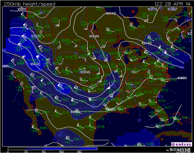
This shows the current jet stream patterns for the country. The large storms are pushing along on the southeastern extent of the trough. Moist tropical air is helping to prolong precipitation over much of the country.

This map shows the current surface conditions over the Midwest. Almost the entire viewing area is overcast and much of it is experiencing some form of precipitation. There is a very large low pressure system centered over the southern edge of South Dakota.

This map shows the current atmospheric conditions for Minneapolis, Minnesota. The KI value shows moderate atmospheric conditions in the form of non-severe storms.


Friday, April 25, 2014

Friday, April 25, 2014

Current Conditions:
Temperature: 54°F
Feels Like: 49°F
Wind: West @ 18 mph, Gusts @ 25 mph
Humidity: 59%
Pressure: 1008.3 mb é

Today is a nice, mild, spring day in the Chippewa Valley. With light winds out of the west and partly cloudy skies filled with cumulus humilis clouds, it is turning out to be a nice day, with expected temperatures to hover in the upper 50's. Looking outside it does seem like there are some clouds with vertical growth, but they are south of Eau Claire, moving east. The extended forecast has a lot of rain in the future. The trough that had developed in the jet stream is now located off to the east, so we are currently in an area of low pressure, which could potentially be the cause of the incoming precipitation. In other parts of the country, severe storms are expected to sweep through Texas and surrounding areas on Saturday.

This map shows the current pressure and frontal systems over the country currently. The string of storms over the Ohio, Pennsylvania area will most likely be dying out soon, as the front that those storms were riding along has become occluded and the moisture supply has been mostly cut off. We are currently being affected by an upper air low pressure trough in our area.

This Accuweather map shows the storms that have the potential to sweep across Texas up to the southwestern tip of Iowa, this Saturday. The storm has the potential to produce hail, tornadoes, and damaging winds.

This map shows the current track of the jet stream over the country. The there is a slight dip in the jet from Wisconsin down towards Florida. As this moves eastward it is likely we will see the development of some precipitation in our area.

This map shows the current surface conditions for the region of the Midwest. A low pressure system seems to be centered above the Upper Peninsula of Michigan currently, which is leading to some cloudy skies in the surrounding areas. Rain is being reported, along with haze, in much of the area to the easternmost side of the viewing area.

This sounding from Minneapolis, Minnesota shows the current atmospheric conditions for the area. LI and KI values show that conditions are relatively stable. The LCL values shows that the cloud deck is relatively low.

Thursday, April 24, 2014

Thursday, April 24, 2014

Current Conditions
Temperature: 43°F
Feels Like: 38°F
Wind: Southeast @ 9 mph
Humidity: 93%
Pressure: 1007.3 mb ê

A cloudy and rainy day in the Chippewa Valley is expected to remain until later this evening. A low pressure system that has not moved much has been keeping rain in the area since late yesterday evening. The occluded front has disappeared, as expected, between yesterday and this afternoon. Current conditions are expected to clear later this evening, as winds shift from the east-southeast to the west-northwest, most likely pushing the storms out of the area. The extended forecast has a bump in temperatures tomorrow into the upper 60's, followed by another drop and more chances for precipitation.

This maps shows the current pressure and frontal systems around the country. Yesterday, there had been an occluded front off of the northern portion of the stationary front that runs through Iowa and Missouri. This front has since disappeared, as it was cut off yesterday. 

This weekend we should expect a cool down in temperatures across the Upper Midwest. There is a potential for rain/snow this weekend, as well. Severe storms are expected to push across the Texarkana area.

This shows the current jet stream patterns over the country. A trough starting around northeastern Montana and dipping all the way down to west Texas is leading to the potential for large snowfall in the Northwest within the next couple days. 

This map shows the current surface conditions for the Midwest region. Currently, moderate to heavy rain is present over much of Minnesota, extending into northwestern Wisconsin. Heavy snowfall is present in the Duluth area. Cloud cover extends west to the eastern border of the Dakotas.

This sounding shows the atmospheric conditions for Minneapolis, Minnesota. Currently, KI values indicate that there is mild atmospheric activity in the area in the form of non-severe storms.

Wednesday, April 23, 2014

Wednesday, April 23, 2014

Current Conditions
Temperature: 42°F
Feels Like: 38°F
Wind: East @ 7 mph
Humidity: 89%
Pressure: 1016.4 mb ê

What started out as a mostly sunny day turned to overcast skies and finally to rain. Today was a chillier day, with highs only reaching the lower 50's. Winds switched between the southeast and east for the better duration of the day. Later in the evening, clouds started moving in, though winds died down a bit as rain moved in. As we head into the weekend, precipitation is expected to remain in the area and temperatures are expected to stay in the 50's. Long term projections have the temperatures remaining low and precipitation remaining constant for the extent of the long term forecast.

This map shows the pressure and frontal systems moving through the country. The low pressure system moving across the Great Plains has the potential to die out, as the presence of an occluded front could mean that it has cut off its moisture supply. We should see a bump in temperatures Friday, as a warm front should be moving through the area.

This Accuweather map shows the predicted weather trends later in the week. Showers, wind, and chilly conditions are expected to be constant in the area. Large storms have the potential to sweep across the Deep South and are following a cold front that is pushing east across the country.

This shows the predicted trends heading into next week. The north-central and northeastern regions of the country are expected to be chilly and wet. The Deep South and southern eastern seaboard are predicted to be affected by severe storms.

This map shows the current jet stream patterns over the country currently. The meandering pattern is bringing cold continental polar air down from central Canada towards the upper Midwest and New England, bringing down temps.

This map shows the current surface conditions for the Midwest. The storm that we are currently experience seem to be coming from the north, as many of the stations around us and to our direct east are not reporting precipitation. Overcast skies are pretty consistent across Minnesota and Wisconsin, as are winds out of the southeast.

This sounding from Minneapolis, Minnesota shows the current atmospheric conditions for the area. The LI and KI values show moderate stability, with some chance of atmospheric activity in the realm of non-severe storms.

Tuesday, April 22, 2014

Tuesday, April 22, 2014

Current Conditions:
Temperature: 48°F
Feels Like: 43°F
Wind: North @ 13 mph, Gusts @ 23 mph
Humidity: 37%
Pressure: 1018.9 mb é

A chillier and windier day in the Chippewa Valley, as we start the first day of our cool down. Temperatures are expected to remain in the low-mid-50's for much of the foreseeable future. Today is supposed to reach a high in the upper 50's with moderate winds for much of the day. The next few days we should expect temperatures to remain constant, while precipitation is possible every day from Wednesday through Friday night. 

This map shows the current pressure and frontal systems moving through the country. Currently, in the west, a series of low pressure systems are bringing some spotty rain to the region. A high pressure dome over the Midwest is leading to a bit of a cool down and winds from the north. In the east, a low pressure trough and cold front are bringing rain to much of the eastern seaboard.

This Accuweather map shows the current predicted trends heading into the middle part of the week. Severe storms are expected to sweep through the TX-OK-KS area. Much of the southeast and southwest are expected to be sunny and warmer. The northwest should see a cool down, thanks to a low pressure system funneling down colder northern air. In the Midwest, we should expect a shift of wind patterns to move towards easterly winds,  as a high pressure system will be residing above the Great Lakes. 

This Accuweather map shows predicted trends for the later parts of the week. We should look for some showers and potentially some windier conditions in the wake of the cold front that is expected to move eastward across the country.

This map shows the current jet stream track over the country. A small trough over the Midwest is helping to funnel down some chillier temperatures, as a coinciding high pressure system is working in tandem to funnel cool central Canada air south.

This map shows the current surface trends over the Midwest. For much of the eastern half of this map, dominant winds are out of the north-northwest. Temperatures seem to be a little chillier throughout the eastern region, as the wind patterns are helping to cool down the temperatures.

This sounding from Minneapolis, Minnesota shows the current atmospheric conditions over the region. Currently, conditions are very stable, with little atmospheric activity.

Monday, April 21, 2014

Current Conditions:
Temperature: 50°F
Feels Like: 45°F
Wind: North @ 12 mph
Humidity: 46%
Pressure: 1015.4 mb é

It was a beautiful day in the Chippewa Valley, as temperatures peaked in the mid-70's. Dominant winds shifted between west and north for the better part of the day, as a high pressure system was spinning off to our west. Clear skies, warm temperatures, and moderate winds were the trend for most of the day. Over the weekend we saw a few spotty periods of rain, but there was not much for precipitation. The next few days we should a bit of a cool down, with most of the temperatures projected to be hovering around the mid-50's.

This maps shows the current pressure and frontal systems in the country. A high pressure system to our north brought winds out of the north and west for most of the day. A warm and cold front to our east are bringing precipitation to the Great Lakes Lowlands region of Canada, though not much else is going on for precipitation over the viewing area.

This Accuweather map shows the expected trends for today's weather. The low pressure system moving through should bring rain to much of the region, excluding the northwest quadrant of Wisconsin. A high pressure system moving in should lead to a continuation of clear skies and a cooling of temperatures.

This map shows the current jet stream patterns over the country. The jet is relatively flat, with a few dips that could potentially develop into a trough.

This shows the current surface data for the Midwest. Temperatures are starting to drop, as the winds have shifted to predominantly northerly winds for much of the region. 

This sounding from Minneapolis, Minnesota shows the current atmospheric trends for the area. There is a small chance for activity in the form on non-severe storms, but it does not seem like there is much going on in the region.


Friday, April 18, 2014

Friday, April 18, 2014

Current Conditions:
Temperature: 32°F
Feels Like: 26°F
Wind: East @ 6 mph
Humidity: 88%
Pressure: 1029.6 mb é

A cloudy but mild day in the Chippewa Valley and warm days ahead as we move into the weekend. Today, we should start to see the rise back to seasonal temperatures. A rather weak high pressure system is right over Wisconsin and winds are currently coming from the east, as the center of the high pressure system is directly to our north. As we head into the holiday weekend, we should expect a very favorable increase in temperature but storm potential for most of the weekend.

Florida is currently experiencing some intense storms with the potential for flooding down there. Up north, an interesting Accuweather story came out today about present ice cover of the Great Lakes in comparison to the last five years. This graph shows that the current level of ice cover will affect the coastal areas, especially, dropping temperatures.

This map shows the current pressure and frontal systems moving across the country. There is currently a string of high pressure systems over the central United States, sandwiched between two lines of low pressure systems on the east and west coasts. 

This graph shows the current ice coverage of the Great Lakes over the last five years. Usually the lakes are less than 5% covered by this time in the year. Currently, they are at 38% coverage. This will continue to affect coastal businesses by not allowing them to continue business. It will also cool the coastal cities substantially.

This shows the current jet stream pattern over the country. The string of high pressure systems coincides with the trough in the jet stream over the center of the country. 

This shows the current surface conditions over the Midwest. Cloudy conditions persist over most of the northern viewing area, while a weak low pressure system is centered over northwestern Wisconsin. Haze is very prevalent in the southwest quadrant of the viewing image.

This sounding shows the current atmospheric conditions for Minneapolis, Minnesota. There is not much going on in the area right now, as conditions are quite stable.

This sounding shows the current atmospheric conditions for Tampa Bay, Florida. The sounding for Tampa Bay is a little more interesting than the sounding for Minneapolis. We see a very unstable air parcel, with an LI value of -4.0 and the KI value of 40. This denotes significant atmospheric conditions with the chance for severe weather.