Wednesday, May 7, 2014

Wednesday, May 7, 2014

Current Conditions
Temperature: 55°F
Feels Like: 51°F
Wind: East @ 14 mph, Gusts @ 20 mph
Humidity: 69%
Pressure: 1010.0 mb ê

A pleasant day in the Chippewa Valley should give way to the potential for severe thunderstorms as the evening progresses, through Thursday. The day started out with increasing cloud cover until it was entirely overcast. A strong, but small, storm cell rolled through the area, with the strongest part of the storm passing just a few miles to our south, traveling northeast. With a warm front and low pressure system pushing in from the south and a cold front and high pressure system moving in from the northwest, conditions are right for some severe weather potential. Tornado watches are out over the Plains region right now and storms predicted to have the potential to bring large hail and damaging winds are being monitored. The next few days should bring storms, with the greatest potential being from this evening through Thursday, during which temperatures are expected to reach up into the mid-upper 70's

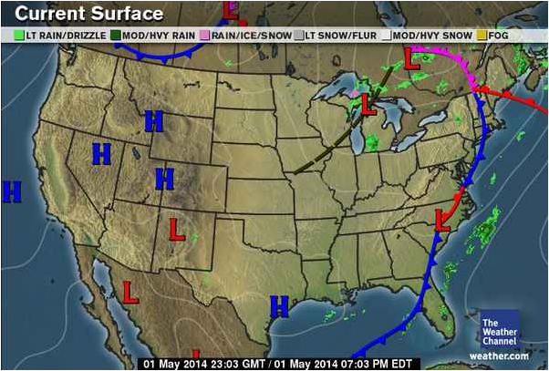
This map shows the current pressure and frontal systems moving across the country. A few areas to take note of and watch are the high pressure system pushing a cold front in the southerly directions, coming from Montana and pushing out. Another area to watch is the low pressure system pushing a warm front to the north. These systems, along with the presence of a dry line in the Texas, Oklahoma, Kansas region have the potential to bring severe storms with tornadic potential.

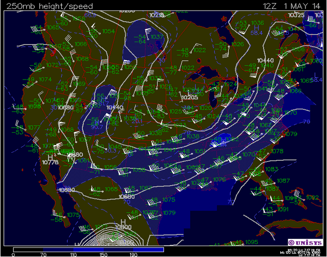
This map shows the current jet stream patterns over the country. The subtropical jet is pushing up, which is allowing the warm front to push north. It appears as though the current track has the potential to take on an omega-high pattern if the meander continues to lengthen.

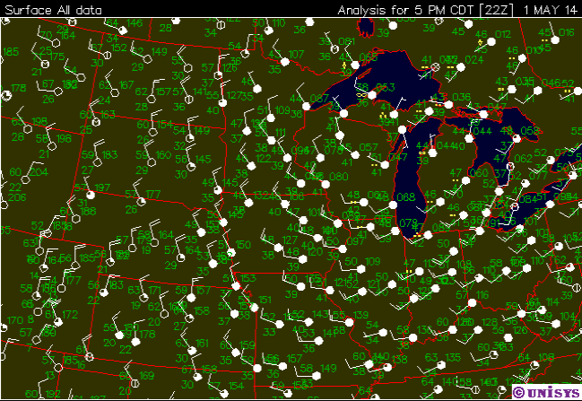
This map shows the current surface conditions for the Midwest region. Currently, the low pressure systems to the south are affecting the region, characterized by counter-clockwise rotating systems. Much of the northern extent of the viewing area is covered by clouds. In our area, dominant winds are out of the east-southeast.

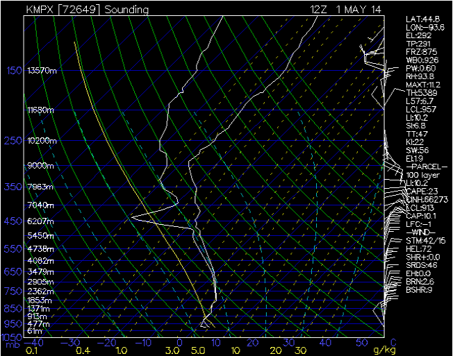
This sounding shows the atmospheric conditions for Minneapolis, Minnesota. Currently, the potential for severe atmospheric activity is moderate, along with the chance for non-severe atmospheric activity.

Tuesday, May 6, 2014

Tuesday, May 6, 2014

Current Conditions
Temperature: 58°F
Feels Like: 58°F
Wind: Southeast @ 16 mph
Humidity: 39%
Pressure: 1016.2 mb ê

We are in for another nice, spring day in the Chippewa Valley, but should start to look out for oncoming storms. Today has been a mild, spring day in the area, with breezy conditions and increasing cloud cover. Highs are predicted to reach into the mid 60's today, with the chance for thunderstorms to kick off this evening and extend through the work week. Thursday is still predicted to be the day with the highest temperatures and, because of the increased temperatures, it also has the highest chance for thunderstorms. This increased chance in thunderstorms is aided by the temperatures because the increased humidity that is available in warmer temperatures helps to fuel the storms.

This map shows the current pressure and frontal systems over the country. A large portion of the country is being affected by the high and low pressure systems in the west, where the stationary front is sitting over the Rockies. To the east a large warm front extends, that is projected to be fully affecting us by Thursday.

This Accuweather map shows the areas predicted to be affected by severe storms this Thursday. This storm as the potential to bring large hail and damaging winds, and Eau Claire is within the predicted area of concern.

This map shows the current jet stream patterns over the country. Currently, the subtropical jet has a bit of an upward bend, which is allowing the warm from to start pushing north and is pushing the subpolar jet northward as well.

This map shows the current surface conditions for the Midwest region. Much of the region is clear, with a few stations reporting partial cloud cover. The northwest is the most cloudy area, with precipitation and haze being reported by a number of different stations. Most of the winds for the area are coming out of the east. This wind direction would make sense, as we are supposed to be getting some larger thunderstorms as the week progresses.

This sounding shows the current atmospheric conditions for Minneapolis, Minnesota. Currently, conditions are rather stable, with little chance for much activity. The cloud deck is at around 793 mb, so a higher level of cloud cover is present.

Monday, May 5, 2014

Monday, May 5, 2014

Current Conditions:
Temperature: 54°F
Feels Like: 50°F
Wind: East @ 12 mph
Humidity: 43%
Pressure: 1017.4 mb é

A partly cloudy day should see a lessening of cloud cover and the development of a nice, spring day. It was a very nice weekend, here in Eau Claire, with a high pressure system moving through, leading to little cloud cover with some breezy conditions. This week we will see a gradual rise in temperatures, peaking on Thursday in the mid-70's. Starting on Tuesday night, thunderstorms are predicted to be possible for the rest of the work week.

This map shows the pressure and frontal systems, currently moving over the country. As we can see, there are two high pressure systems to our northeast, that were affecting us this weekend, leading to clear skies and breezy conditions.

This Accuweather map shows the current predicted severe thunderstorm risk for the middle of the week. Most of Wisconsin is at risk, and the area extends all the way down to Texas.

This map shows the current jet stream patterns over the country. The jet is much flatter, allowing for warm air to push northward and warm our area up more. 

This map shows the current surface data for the Midwest. Much of the northern portion of the map is covered by clouds, while there is not much of a visible pattern for wind directions.

This map shows the current atmospheric conditions for Minneapolis, Minnesota. According to the KI value, there is a potential for some atmospheric activity in the form of non-severe storms. The cloud level is at 739 mb.


Friday, May 2, 2014

Friday, May 2, 2014

Current Conditions
Temperature: 51°F
Feels Like: 51°F
Wind: Southeast @ 9 mph
Humidity: 61%
Pressure: 1004.6 mb ê

A little rain should be expected on and off, as we move towards less rainy conditions for the weekend. As we move into the weekend we should be able to look for a couple of trends. The first of those is a small cooldown, as a weak cold front moves through, dropping temperatures just a few degrees. The other trend should be a break in the constant precipitation we had been experiencing. While there is a chance that it will be raining today, the weekend is expected to be rather clear, with temperatures in the mid-50's. Moving into next week, we should look for some more precipitation, but overall a warming trend, with temperatures climbing back into the 60's.

This map shows the current pressure and frontal movements over the country. As we can see, the low pressure system that had been bringing near constant rain to the area is currently up near Hudson Bay. A small cold front is moving towards us, which is expected to cool temperatures for a few days. Overall, the country is mostly being affected by high pressure systems, except for the northern central portion of the country.

This Accuweather map shows the projected trends for next week. Hopefully, these will hold true, because this model has the jet stream pushing north and warm temperatures expanding out from the Texas panhandle region.

This map shows the current jet stream patterns over the country. Currently, we can see the trough starting to really recede back north, as the subtropical jet is starting to get another foothold on the area.

This map shows the current surface conditions for the region of the Midwest. Currently, much of the eastern half of the viewing area is covered by clouds, but winds from the west should start to push the clear skies towards us.

This sounding from Minneapolis, Minnesota shows the current atmospheric conditions in the area. Currently, there is a very small chance for atmospheric conditions in the area, but if they occur they should be expected in the form of non-severe conditions.


Thursday, May 1, 2014

Thursday, May 1, 2014

Current Conditions:
Temperature: 46°F
Feels Like: 41°F
Wind: Northwest @ 10 mph
Humidity: 79%
Pressure: 1008.1 mb é

Less rain today, but misty conditions stayed around as the low pressure system is finally starting to move out of the area. The low pressure system that had been bringing precipitation to the area for the last week has finally started to move to the northeast after moving very slowly through the country. A number of high pressure systems are forming and moving across the Rockies, currently. Conditions are expected to warm up as we head into the weekend and next week, while the chance for rain will decrease as well. Tomorrow there is a decent chance for some rain but then it should clear up for the weekend.

An interesting weather pattern is starting to take form in the Pacific as El Nino pattern seems to be forming. An El Nino pattern has a massive influence on the weather patterns across the entirety of the Americas. El Nino patterns will lead to warmer and wetter conditions across the entire region. In the images below, there is a number of pictures that show the movement of the warm mass of water moving through the Pacific.

The large low pressure system with the mid-latitude cyclone that has been moving across the country is now centered to the north of the Great Lakes. The system is weakening as the presence of the large occlusion signifies that the storm is cutting off its moisture supply.


This map shows the current jet stream patterns across the country. Currently, we are sitting in the middle of the jet stream trough. The trough is getting smaller and moving north compared to where it was in the past week.

This map shows the current surface conditions over the Midwest. Conditions over much of the eastern half of the viewing area are completely overcast, tapering off moving west. Rain is still present, mostly in the northeast.

This sounding from Minneapolis, Minnesota shows the current atmospheric conditions in the area. There is a chance for some atmospheric activity in the form of non-severe conditions.

Wednesday, April 30, 2014

Wednesday, April 30, 2014

Current Conditions:
Temperature: 44°F
Feels Like: 39°F
Wind: Northwest @ 9 mph
Humidity: 89%
Pressure: 1005.9 mb é

Overcast and rainy conditions continue, though their likelihood should decrease as the week progresses. Today has been entirely overcast, with drizzle on and off for the better part of the day. The large low pressure system that has been leading to all the precipitation is currently centered directly over the state, which will allow for continued overcast conditions and a potential for precipitation until around the end of the weekend. High pressure systems in the west should start to move east and begin clearing skies. We should also expect a bump in temperatures back into the mid-50's as we hit the second half of the week. 

This map shows the pressure and frontal systems currently over the country. The main cold front that is pushing that has been pushing the storm eastward has developed another occlusion, which will most likely lead to a weakening of the system, as it is cutting off its moisture supply. There are a few high pressure systems that will be pushing through, helping to clear skies in the latter part of the week.

This is an Accuweather map that is predicting summer trends. Conditions for our area, for much of Minnesota and the Dakotas, and for Florida and Georgia and expected to be typical. Unfortunately for the southwest, the drought is expected to continue to quench the area. 

This map shows the current jet stream patterns for the country. The large circular area in the center coincides with the low pressure system that has been affecting much of the country since Sunday. This trough has been pretty stuck for some time now, though it appears to be shifting to the east.

This map shows the current surface data for the Midwest. Like much of the preceding week, conditions are very overcast for most of the viewing area, with precipitation spotty, but present over a wide range of the map.

This sounding shows the atmospheric conditions for Minneapolis, Minnesota. Currently, there is some atmospheric activity in the form of non-severe storms. The cloud deck is also very low, as the humidity level shows very saturated conditions.


Tuesday, April 29, 2014

Tuesday, April 29, 2014

Current Conditions
Temperature: 38°F
Feels Like: 29°F
Wind: Northeast @ 15 mph, Gusts @ 23 mph
Humidity: 93%
Pressure: 1003.1 mb ê

Rain persists and will continue to remain in the forecast for the next week. It has been a rainy last few days for much of the country, as precipitation continues to occur, thanks to a very large jet stream trough allowing for the development of a large low pressure trough/mid-latitude cyclone. A mix of conditions are currently affecting us, as we have a massive high pressure dome funneling cold air down from central Canada, a large mid-latitude cyclone that is continuing to move its way (slowly) across the country. It will be interesting to see what happens, as there is a chance that the storm could start to die off. The presence of an occluded front in the direct center of the trough could mean that the storm is cutting off its moisture supply a bit, through its relative proximity to the Great Lakes could help boost that moisture pool. Over the next few days, we should expect a gradual rise in temperatures, accompanied by a continuing chance for precipitation.

This map shows the current pressure and frontal systems for the country. As discussed, most of the eastern United States is being affected by a very large mid-latitude cyclone that has been moving across the country at a very slow pace. There is a chance that this will die out some, as the presence of occluded fronts signify that it could be cutting off its moisture supply. 

This water vapor map of the eastern United States shows the current concentrations of water vapor over the country. The classic comma shape shows helps to illustrate the location of the mid-latitude cyclone affecting much of the country. There is an especially high concentration over the Alabama and Florida coastlines, where there are currently some severe storms. A large dryline is following in the wake of the storm. There are very defined dry conditions where the high pressure dome is spinning, visible in North Dakota and to the north.

This map shows the current jet stream track for the country. There is a very large trough in the jet stream, currently, as a large high pressure system in central Canada is helping to push the jet south. This is allowing for the large low pressure trough to form that has created this mid-latitude cyclone.

This map shows the current surface data for the Midwest. Much of the viewing area is still completely overcast, with some exceptions to the northwest and southeast. Precipitation is present, being reported by many of the stations, with a few even reporting heavy snowfall.

This sounding shows the current atmospheric conditions for Minneapolis, Minnesota. Currently, there is some form of atmospheric activity in the form of non-severe weather.