Current ConditionsTemperature: 43°FFeels Like: 34°FWind: East @ 22 mph, Gusts @ 32 mphHumidity: 86%Pressure: 1006.3 mb ê
Rain will continue to plague the Chippewa Valley for most of the foreseeable future. Over the weekend, Saturday was a windy but beautiful day. Sunday started the precipitation, with multiple large storms working their way through the area. With a very high moisture concentration moving across the country, these storms should sustain themselves for some time. Temperatures should stay in the upper 40's for the rest of the week.
 |
| This map shows the pressure and frontal systems from very early this morning. A massive dry line was pushing across Texas. Which has aided in the development of a number of very large storm cells in the Mississippi/Louisiana area. |
 |
| This map shows the water vapor content over the eastern portion of the country. Early this morning there was a very large concentration of moisture over the southern portion of Illinois. The dry line can be seen over Texas, with two areas of very moist conditions. |
 |
| This map shows the most recent pressure and frontal systems over the country. The dry line is no longer visible, however a line of storms that is gaining strength over the Mississippi/Louisiana/Tennessee area. |
 |
| This map shows the most recent water vapor conditions over the eastern United States. The dry line is not as strongly visible, even though there are drier conditions on the west side of the cold front. On the east side, being pushed but the cold front, is a massive concentration of moisture, directly in line with the predicted severe storms over the next couple days. |
 |
| This Accuweather map shows the potential for severe storms Today. The highest risk for severe storms is directly in line with the area of highest water vapor. |
 |
| This Accuweather map shows the predicted movement of the severe weather for Tuesday. Fueled by warm maritime tropical Gulf air, these storms should push to the northeast, following a stationary front. |
 |
| This Accuweather map shows the predicted jet stream patterns and conditions for the middle of the week. This is a good example of an Omega high jet stream pattern. The trough is experiencing unseasonably cool temperatures, while the area to the east and west of the trough is experiencing warmer temperatures. |
 |
| This shows the hydrograph for the Chippewa River at Eau Claire, which shows the current and expected rise of the Chippewa River. The river is already in the action stage and, given the current precipitation trends, river levels are expected to rise another four feet by Thursday. |
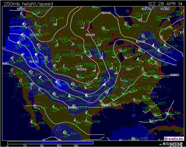 |
| This shows the current jet stream patterns for the country. The large storms are pushing along on the southeastern extent of the trough. Moist tropical air is helping to prolong precipitation over much of the country. |
 |
| This map shows the current surface conditions over the Midwest. Almost the entire viewing area is overcast and much of it is experiencing some form of precipitation. There is a very large low pressure system centered over the southern edge of South Dakota. |
 |
| This map shows the current atmospheric conditions for Minneapolis, Minnesota. The KI value shows moderate atmospheric conditions in the form of non-severe storms. |
No comments:
Post a Comment