Temperature: 47°F
Feels Like: 39°F
Wind: East @ 21 mph, Gusts @ 28 mph
Humidity: 46%
Pressure: 1014.2 mb ê
A collective sigh should be heard, as it seems we have missed the large snowstorm that blew north of us. Older models had a large storm coming our way and we were predicted to be right in the thick of it. However, as it has been true with many of the models this season, the storm blew to our north and instead is heading/has arrived in Duluth. Winds started were relatively calm around 9-11:00 times morning, however started to pick up around 11:30ish and steadily risen since, as the low pressure system has eastward and has pushed the main part of the storm north. The high pressure systems that were affecting the central portion of the country have been pushed east by the low pressure system moving in, which has in turn pushed the stationary front that was bombarding the east coast out into the Atlantic. So, while we are still expected to get precipitation within the next 12 hours, it is not expected to be snow, so much as rain. Over the next few days we should look for the potential for more precipitation, but a gradual warming trend, as the jet is starting to flatten back out, allowing for warm air to push north again.
 |
| This map shows the current pressure systems and frontal activity over the country. As discussed above, the low pressure trough that is currently bringing a midlatitude cyclone to our north, is pushing eastward. It has helped to push the high pressure dome east that had currently been aiding in our chilly temperatures. |
 |
| This shows the expected precipitation possibilities for the evening. We are right near the edge, here in Eau Claire, between snow and wintry mix. Depending on where the low pressure system tracks will have an impact on what we get. |
 |
| This shows the potential snowfall for Thursday. Once again, we are on the very edge of the area expected to get snow, so it is hard to say if we can expect it or not. As the normal trend has been, Duluth/Superior should expect to get pounded by this storm as well. |
 |
| This shows the current jet stream activity for the country. After a few days of being plagued by a very deep trough, the Midwest should be happy to see the jet stream starting to level back out. This leveling should help to allow warmer temperatures to push back to the north and bring us back to seasonally normal temperatures. |
 |
| This shows the current surface conditions for the Midwest. Lots of cloud cover is present along the northern half of the viewing area, which the low pressure system is the cause. Visible is the center of the system over southwestern Iowa, moving east-northeast. |
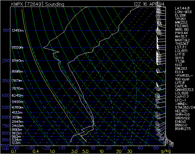 |
| This sounding shows the atmospheric conditions for Minneapolis, Minnesota. Currently, there is a slight possibility for nonsevere activity, but not much else is significant in the area. |
No comments:
Post a Comment