Current Conditions
Temperature: 31°F
Feels Like: 20°F
Wind: Southeast @ 17 mph, Gust @ 24 mph
Humidity: 52%
Pressure: 1016.6 mb ê
We are starting to warm up here, once again, in the Chippewa Valley. The high pressure system that had brought clear skies and chilly temperatures has moved through the area. A decently sized low pressure system is pushing its way through now, currently centered over the eastern side of Montana and Wyoming. Temperatures are expected to rise and peak on Sunday, with a predicted high in the low 50's. Currently, skies are partly cloudy, with what appear to be altocumulus clouds, better known as a mackerel sky. Tonight, we should look for a little rain, with the potential for snowfall after midnight, no accumulation is expected. The jetstreams appear to be doing some interesting stuff right now. The subtropical jet seems to be pushing northward slightly, allowing for a push of warmer temperatures. The subpolar jet appears as to be meandering quite substantially, allowing for areas of warmer and frigid temperatures, depending on the location in respect to the meander. It also appears as though there is a large upper atmosphere low pressure trough, centered just north of Hudson Bay.
 |
| This map shows the pressure systems over the country. There are three very prominent systems it seems like, currently. A conglomerate of low pressures systems over the Rockies is affecting everything east until Wisconsin down to Louisiana. A high pressure dome is affecting most of the eastern US from Illinois down to eastern Louisiana, eastward. Finally, a very strong low pressure system is affecting the New England area, with what appear to be potential blizzard conditions. |
 |
| The Accuweather prediction for the end of the week has the Deep South and Eastern Seaboard getting bounded by storms for most of the latter portion. "Colder" air will persist over the Midwest, though here it will seem quite nice in comparison. Dry temperatures will remain in the Desert Southwest, as has been the current trend with the drought going on down there. |
 |
| An interesting map just produced that shows the forecast for planting in the country. Most of the country is in good shape, however there are three main areas to pay attention to. The Desert Southwest is still struggling with a crippling drought. On the other hand, the Deep South, up through about central Illinois and Indiana are too wet and will inhibit crop growth. In the upper Midwest, the ground is frozen too far down and will lead to delays in the planting season. |
 |
| This map shows a larger scale view (most of North America) of the current jetstream activity. The low pressure system over Hudson Bay is still quite powerful, and there seems to have been the formation of another smaller system off the southeast corner. There are a number of very large bends, of which I discussed earlier. The subtropical jet can be seen up through about the center of the country, pushing up slightly. |
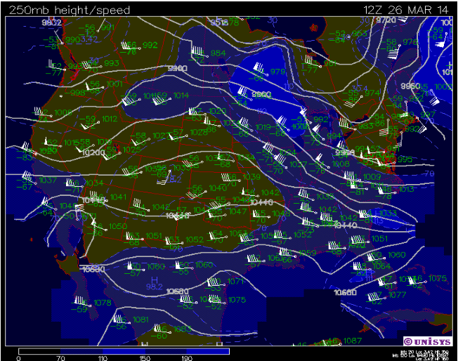 |
| This is a small scale view of the US and the current jetstream activity. This just shows what was described above at a more zoomed in scale. |
 |
| This current surface map shows the temperatures and wind directions for the Midwest. The center of the large conglomeration of low pressure systems seems to be directly over the corner of Nebraska and South Dakota, bordering Wyoming. |
 |
| This sounding from Minneapolis, Minnesota shows a large thermal inversion at about 850 mb. The LI and KI values show no significant atmospheric activity currently over the area. |
No comments:
Post a Comment